The trajectories and challenges of the development of inner peripheries in the new conditions of cohesion post SARS-CoV-2
3. Concept and work plan
3.1. General work plan, specific research goals
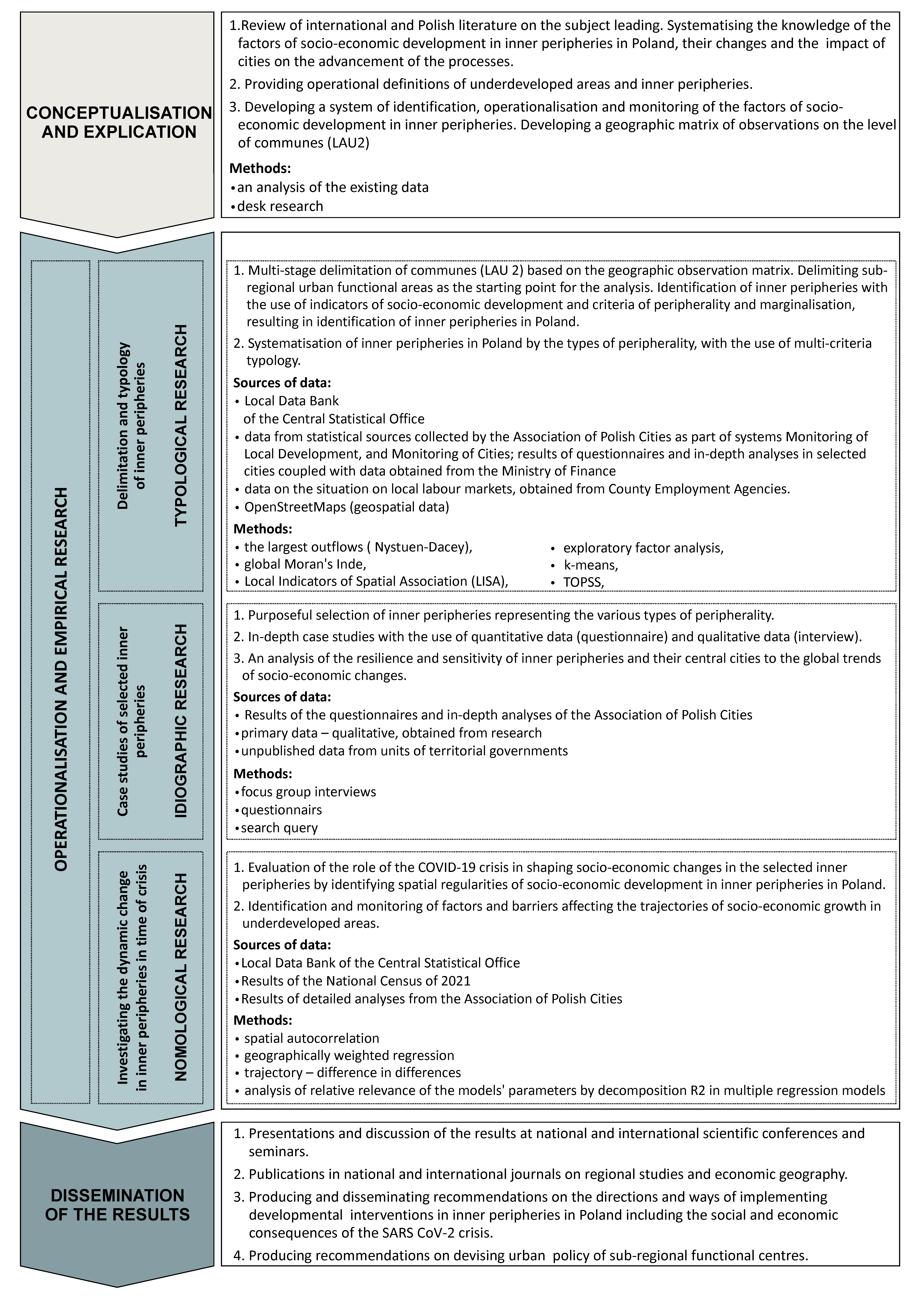
In our approach, we have assumed that spatial differences are a natural feature of development and, following the concept of uneven development, imbalance in economy is the driving force of growth. In our opinion, these conditions call for an intervention which should take into consideration the idiosyncrasies of the specific areas’ resources, i.e. in compliance with the place-based approach, in order to streamline the growth conditions and counteract its excess polarisation. The research will be conducted in two spatial arrangements: national and three or four selected research areas – functional urban regions – which represent case studies. The project will be divided into three basic stages of operationalization and empirical research:
- Delimitation and typology of inner peripheries within a set of functional regions of medium-sized and small towns.
- Case studies of three or four selected inner peripheries.
- Research into the dynamic changes in inner peripheries in the time of crisis.
Stages one and three of the research will be completed on the national (Polish) scale by means of predominantly secondary sources of data and quantitative analyses. Stage two will be carried out on a local scale by means of primary data as well as qualitative and quantitative methods.
The sequence of the stages is anything but accidental. Stage one of the research (of typological nature) will allow us to choose the research areas representing various types of inner peripheries for stage two (idiographic research). At the same time, in the first stage of the research, indices of changes will be selected, which will be analysed at stage three. The third stage will be of nomological nature: its goal will be the quantitative verification of the regularities and dependencies the hypothetical definition of which will be a result of stage two. Below we have described in more detail the three stages of the research.
The research plan is supplemented by two additional stages: the preliminary stage of literature review, and the summarising stage of disseminating the results. In fact, these two stages will be completed in parallel throughout the project time: the preliminary stage will be continued by means of monitoring the literature and results of other studies and economic and political trends which are related to the issues at hand. The results of the specific stages of empirical research will be regularly subjected to academic discussion as the project goes ahead.

In the research, primary data derived from the project will be used combined with secondary sources of data. The entities involved in the project have at their disposal the equipment (one PC is planned to be purchased) and software to be used on the course of the research.
Delimitation and typology of inner peripheries
Defining the range and types of inner peripheries has been largely covered in literature on the subject (ESPON, 2018; Musil and Muller, 2008; Śleszyński et al., 2017). Former research was typically carried out in a spatial arrangement of (Polish) communes or statistical sub-regions (on a European scale – EPSON, 2018). The research has been based on statistical data provided by the Central Statistical Office (Eurostat) and supplemented by GIS data on transport accessibility. In the research, methods based on quantiles, standardisation of variables or arbitrary setting value thresholds have been used (Śleszyński et al., 2017). This approach resulted from the application-related importance of the research (to the formulation of the regional policy) which necessitates application of measurable and comparable criteria for administrative units. Since our project does not have an application-related dimension, it is not affected by these limitations.
By referring to the experiences from the former research, we intend to apply an original approach to sources of data, analysis methods as well as using reference units based on actual functional relations between cities and rural areas rather than exclusively on the administrative and statistical division into counties and statistical sub-regions. Inner peripheral nature is by definition a multi-scale phenomenon. From the point of view of theory of the centres, inner peripheralisation may indicate weakening the functions of the core settlement centres (Wójcik, 2011). In the Polish context, this may indicate e.g. a town or a village with a communal administration office, a county capital city or a larger city of sub-regional character, e.g. from among the cities which in 1999 lost their status of province capital cities (Sokołowski, 2011). Delimitation of inner peripheries on the basis of the statistical features of communes may limit perception of medium-sized and small towns losing the function of affecting a specific commune as the reason for peripheralisation. For this reason, on a national scale, we have adopted the basis of delimitation and typology of inner peripheries in the form of all the urban functional regions of small and medium towns defined as areas outside the strong influence of regional centres i.e. capital cities of provinces. These regions tend to be nodal rather than uniform (Whittlesey 1954;). This indicates that they have been defined on the basis of functional relations – commuting to work, to school, trade and personal relations – between a city and the surrounding areas. The way of delimiting these functional regions is relying on information on commuting to work.
A multi-stage typology of the problem areas developed after the delimitation will take into consideration various characteristics, e.g. the size, the size of the centre, the specific problems. The delimitation and typology will result in a selection of the areas to be analysed in stage two and indicators for analyses in stage three of the project.
Case studies of three or four selected inner peripheries
The areas (urban regions) selected for the analysis will be selected to represent various types of inner areas; as a result, they will serve as examples representative of the other inner peripheries with similar characteristics.
At this stage of the research we plan studies of the development trajectories of the areas, identifying their specific sensitivities, resilience and potential consequences of the latest situation for growth. In order to achieve it, it will be necessary to collect factographic information; for these areas, statistical data obtained at an earlier stage will be supplemented with more precise and, most importantly, topical unpublished information from county offices. It will be information on entrepreneurship and local finance, from county employment agencies on employment and unemployment, from county offices on building construction intensity as well as opinions and attitudes of representatives of various groups of stakeholders who affect the development of these areas. The groups of stakeholders include primarily representatives of local authorities (mostly communal), entrepreneurs operating in a specific area and local residents. In collecting opinions and attitudes, individual interviews and focus groups will be used, coupled with an analysis of the existing documents.
The research results at this stage will allow to accomplish some of the project’s research goals. What is more, a comparison of the situation in the specific research areas will provide bases for constructing hypotheses on the differences in the developmental trajectories between the various types of inner peripheries. The correctness of the answers will be verified at stage three of the project.
Dynamic research into the changes in inner peripheries in the time of crisis
Stage three of the research will follow stage one and two and will draw on the knowledge accumulated in the two previous stages. At the same time, the time lapse (the stage of the research procedure is planned for the last years of the project) will allow to make use of the latest sources of statistical information. Firstly, we should assume that we will already have had statistical data for after the Covid-19 pandemic and, as a result, we will have been able to analyse quantitatively the event’s impact on the indicators developed at stage one of the research. Secondly, as we have planned, we will have access to the results of the Polish Census of 2021 (data not available in the latest public statistics) that will provide an opportunity to capture the trends for the last ten years.
3.2. Results of preliminary research
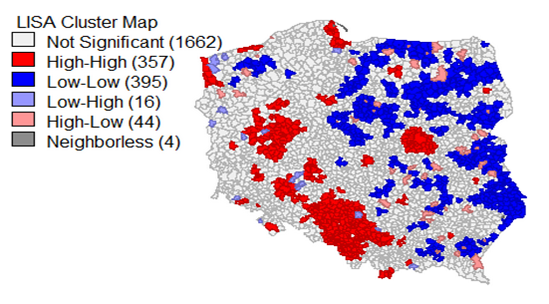
Systematic analyses of the reasons, changes and consequences of the social differences in the socio-economic development have been carried out by the project team manager for many years. The starting point for this research was systematising the factors of regional development, taking into consideration the consequences of the intervention of the regional policy following Poland’s integration with the European Union (Churski, 2008). Next, the scope of the research was put into more detail with respect to the region of Wielkopolska and the diversity of the economic, social and place-based cohesion within the region (Churski, 2009). The results triggered off more in-depth analyses of the local conditioning defined as the fundamental determinants of developmental processes on any spatial scale. This led to a comprehensive study on the changes and factors of the spatial distribution of economic growth and economic stagnation areas in central and Eastern Europe (Churski, 2014). To provide more details to the studies on the identification of developmental regularities in the space, a research on regional specialisation in the conditions of heterogeneous space has been carried out (Kopczewska, Churski et al, 2017). By taking into consideration the dynamically changing global conditions, the contemporary challenges of the regional policy have also been identified and attention has been drawn to the need for re-contemplating the ways of identifying, interpreting and affecting the factors of socio-economic development on various spatial scales in Europe and Poland alike (Churski et al, 2020b). The resulting experience allows us to better understand the conditions and regularities behind the analysed processes and therefore they help to better select the indices, to apply methods appropriate to the problems and to hold a discussion and in-depth explanation. Analyses carried out for the communes in Poland indicate (Pietrzykowski 2019) that in 2004-2016 we dealt with decreasing dispersion in the socio-economic development between the regions of Poland. Therefore, sigma-type convergence occurred (a synthetic measure of development has been used, calculated by means of a multi-dimensional comparative analysis). The analyses also indicate occurrence of beta-type convergence which took place in all the communes. The applied techniques of spatial analysis also indicate strong positive spatial auto-correlation in the entire analysed time. Moran’s I index presents high positive values accompanied by high values of the standard score referring to the distribution of the probability of the random variable. Getis and Ord statistic (G) amounted to 0.000004 while the standard score equalled 4.597565, which means that with this standard deviation, the likelihood of spatial random distribution is much below 1%. These high values of Moran’s I index indicate the likelihood of clusters of similar values. The results of an analysis of local spatial dependencies confirm the suppositions. Statistically significant clusters have been identified for approximately 1/3 of the communes. Figure 1 shows a clear-cut division between the western part of the country with prevailing clusters of communes with high values (high-high) and the eastern part with clusters of communes characterised by low values (low-low) of the Synthetic Growth Indicator (SGI) except for the Warsaw agglomeration.

Figure 1. Local indicator of spatial auto-correlation for the synthetic growth indicator, mean values for 2004-2016 (queen weight matrix)
Another important finding is the occurrence of clusters of communes with high SGI values around robust cities – capitals of provinces (the agglomerations of Warsaw, Silesia, Poznań, Łódź, Szczecin, the Tricity) where cumulative growth prevails. At the same time, it is hard to identify any scale of impact around smaller county towns which may be an indication of lack of effective creation of sub-regional growth poles and the resulting reduced growth opportunities for inner peripheries. The clusters are not symmetrical in a spatial sense but rather, stretched mainly toward the west (see the Warsaw agglomeration). The course of the curves depicting the scope of variation and Moran’s index I (Figure 2) indicate an increase in the spatial regularities accompanied by convergence processes which indicates prevalence of contact diffusion. This means that the adjacent areas are increasingly co-dependent while the diffusion of growth processes takes a mild course together with the progressing migrations yet it has a limited spatial scope.
Figure 2. The coefficient of variation (dashed line) and Moran’s I index (queen weight matrix, solid line) of the synthetic growth indicator for all types of communes in 2004-2016
However, the fit of the regression models is largely affected by the applied research method as well as the nature of the variables used. While in the case of the synthetic measure of the socio-economic development, taking into account social and environmental aspects, the research indicates convergence in a majority of place-based sections and the analysed time series (except for the years of the credit crunch of 2008-2010 and its aftermath), application of the model of the GDP itself as reference of the production level by territories leads to different conclusions. In 2018-2019, the team members carried out research aimed at identifying the impact of cohesion policy on economic growth in regions and a change in the developmental discrepancies between regions (Dubownik et al., 2019). In the research, the method of geographically weighted regression was employed as well as selected measures of variation (Hoover and Gini coefficients of variation). A comparison of the GDP values of actual prices in 2006 and 2015 allowed us to conclude that at the time of implementing funds from the EU programmes from the 2007–2013 budget, the differences in the GDPs in provinces and sub-regions actually grew. On the level of provinces as well as sub-regions, beta-type divergence occurred. This indicates that the EU funds earmarked for cohesion policy and the Common Agricultural Policy did not contribute to closing the developmental gaps in the country or their impact did not balance off the other factors opposing convergence. Interestingly, developmental divergence was more distinct in the case of provinces than sub-regions. Therefore, the differences in the levels of development of entire regions occurred faster than the differences within the provinces. On the one hand, this indicates yet again the ineffectiveness of cohesion policy targeted at supporting entire economically weaker provinces, rather than smaller units. Perhaps the growing differences in the level of development between provinces stem from the diverse skills in managing the EU assistance funds, mainly funds from the Regional Operational Programmes. On the other hand, the small increase in the differences in the economic growth of sub-regions shows that in the analysed time, economic growth did not concentrate in the centres of the specific regions at the expense of the regional peripheries. This is also confirmed by the results of the dynamics of the GDP growth in 2006-2015 when higher growth (106%) was recorded in peripheral sub-regions while central sub-regions enjoyed GDP growth of approximately 70%. The changes to GDP lead to a conclusion that there is a positive trend against the economic dominance of the central areas over peripheral areas in an intra-regional arrangement which is hard to notice on the inter-regional level (Churski et al., 2020a). Therefore, there is a need to produce models that will provide more information about factors and constraints of inner peripheries development, as well as information if the dynamics of these processes are conducive to the convergence of the level and quality of life in various regions of the country.


